


coteaux de Rontignon

CABERMAT
User
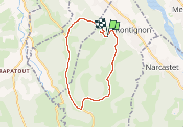

Length
7.4 km

Max alt
349 m

Uphill gradient
212 m
Km-Effort
10.2 km

Min alt
201 m

Downhill gradient
214 m
Boucle
Yes
Creation date :
2024-10-14 08:43:59.129
Updated on :
2024-10-14 11:56:47.304
3h11
Difficulty : Medium

FREE GPS app for hiking
 SityTrail
IGN / Geographical institutes
SityTrail Plus
The world is yours!
About
Trail Walking of 7.4 km to be discovered at New Aquitaine, Pyrénées-Atlantiques, Rontignon. This trail is proposed by CABERMAT.
Photos

Positioning
Country:
France
Region :
New Aquitaine
Department/Province :
Pyrénées-Atlantiques
Municipality :
Rontignon
Location:
Unknown
Start:(Dec)
Start:(UTM)
715994 ; 4792995 (30T) N.
Comments