


SityTrail - golf empereur_0224

Thyves
User
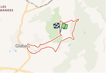

Length
6.8 km

Max alt
135 m

Uphill gradient
119 m
Km-Effort
8.4 km

Min alt
95 m

Downhill gradient
120 m
Boucle
Yes
Creation date :
2024-10-14 12:25:10.265
Updated on :
2024-11-15 13:51:37.682
1h54
Difficulty : Medium

FREE GPS app for hiking
 SityTrail
IGN / Geographical institutes
SityTrail Plus
The world is yours!
About
Trail Walking of 6.8 km to be discovered at Wallonia, Walloon Brabant, Genappe. This trail is proposed by Thyves.
Description
guide : Luc Bernard
Positioning
Country:
Belgium
Region :
Wallonia
Department/Province :
Walloon Brabant
Municipality :
Genappe
Location:
Ways
Start:(Dec)
Start:(UTM)
604428 ; 5610263 (31U) N.
Comments