


up

raygautier
User

Length
15.6 km

Max alt
393 m

Uphill gradient
447 m
Km-Effort
22 km

Min alt
103 m

Downhill gradient
451 m
Boucle
Yes
Creation date :
2024-10-13 07:00:25.447
Updated on :
2024-10-15 18:13:01.852
5h02
Difficulty : Very difficult

FREE GPS app for hiking
 SityTrail
IGN / Geographical institutes
SityTrail Plus
The world is yours!
About
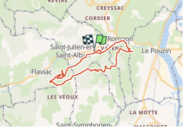
Trail Walking of 15.6 km to be discovered at Auvergne-Rhône-Alpes, Ardèche, Saint-Julien-en-Saint-Alban. This trail is proposed by raygautier.
Positioning
Country:
France
Region :
Auvergne-Rhône-Alpes
Department/Province :
Ardèche
Municipality :
Saint-Julien-en-Saint-Alban
Location:
Unknown
Start:(Dec)
Start:(UTM)
635082 ; 4957182 (31T) N.
Comments