


hamars la vallée

marco14
User
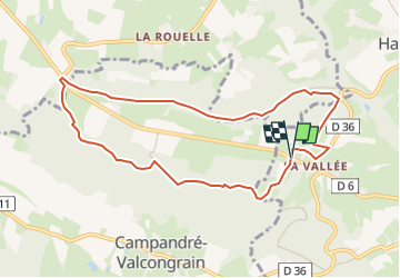

Length
9 km

Max alt
249 m

Uphill gradient
204 m
Km-Effort
11.7 km

Min alt
121 m

Downhill gradient
202 m
Boucle
Yes
Creation date :
2024-10-16 11:53:40.48
Updated on :
2024-10-16 12:09:55.354
2h40
Difficulty : Easy

FREE GPS app for hiking
 SityTrail
IGN / Geographical institutes
SityTrail Plus
The world is yours!
About
Trail On foot of 9 km to be discovered at Normandy, Calvados, Le Hom. This trail is proposed by marco14.
Positioning
Country:
France
Region :
Normandy
Department/Province :
Calvados
Municipality :
Le Hom
Location:
Hamars
Start:(Dec)
Start:(UTM)
678488 ; 5428770 (30U) N.
Comments