


Rando château de BOMBON - MONTJAY - 6 KM

jeanmarcMasson
User GUIDE
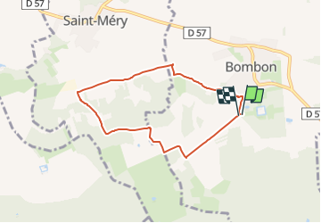

Length
6.2 km

Max alt
106 m

Uphill gradient
66 m
Km-Effort
7.1 km

Min alt
75 m

Downhill gradient
65 m
Boucle
Yes
Creation date :
2024-10-16 13:38:18.728
Updated on :
2024-10-16 13:40:33.764
1h36
Difficulty : Medium

FREE GPS app for hiking
 SityTrail
IGN / Geographical institutes
SityTrail Plus
The world is yours!
About
Trail Walking of 6.2 km to be discovered at Ile-de-France, Seine-et-Marne, Bombon. This trail is proposed by jeanmarcMasson.
Positioning
Country:
France
Region :
Ile-de-France
Department/Province :
Seine-et-Marne
Municipality :
Bombon
Location:
Unknown
Start:(Dec)
Start:(UTM)
489390 ; 5379239 (31U) N.
Comments