


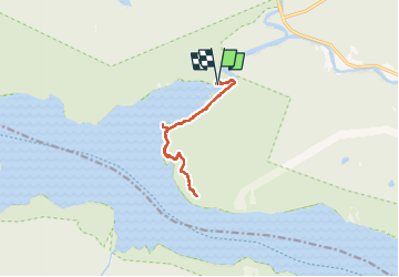
Rando sentier le Fjord de Saguenay 12km

jeanmarcMasson
User GUIDE

Length
11.4 km

Max alt
185 m

Uphill gradient
251 m
Km-Effort
14.7 km

Min alt
1 m

Downhill gradient
253 m
Boucle
Yes
Creation date :
2024-10-04 14:07:18.724
Updated on :
2024-10-16 13:47:39.818
3h11
Difficulty : Difficult

FREE GPS app for hiking
 SityTrail
IGN / Geographical institutes
SityTrail Plus
The world is yours!
About
Trail Walking of 11.4 km to be discovered at Quebec, La Haute-Côte-Nord, Sacré-Coeur. This trail is proposed by jeanmarcMasson.
Photos


Positioning
Country:
Canada
Region :
Quebec
Department/Province :
La Haute-Côte-Nord
Municipality :
Sacré-Coeur
Location:
Unknown
Start:(Dec)
Start:(UTM)
429863 ; 5346111 (19U) N.
Comments