


cambremer

semaine
User
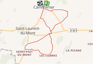

Length
8.3 km

Max alt
150 m

Uphill gradient
135 m
Km-Effort
10.1 km

Min alt
96 m

Downhill gradient
136 m
Boucle
Yes
Creation date :
2024-10-17 09:26:08.014
Updated on :
2024-10-17 09:26:41.692
2h18
Difficulty : Medium

FREE GPS app for hiking
 SityTrail
IGN / Geographical institutes
SityTrail Plus
The world is yours!
About
Trail Walking of 8.3 km to be discovered at Normandy, Calvados, Cambremer. This trail is proposed by semaine.
Positioning
Country:
France
Region :
Normandy
Department/Province :
Calvados
Municipality :
Cambremer
Location:
Cambremer
Start:(Dec)
Start:(UTM)
284711 ; 5448437 (31U) N.
Comments