


Crest

raygautier
User
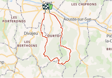

Length
14.6 km

Max alt
413 m

Uphill gradient
478 m
Km-Effort
21 km

Min alt
198 m

Downhill gradient
501 m
Boucle
No
Creation date :
2024-10-17 06:57:26.0
Updated on :
2024-10-17 12:55:11.136
5h56
Difficulty : Very difficult

FREE GPS app for hiking
 SityTrail
IGN / Geographical institutes
SityTrail Plus
The world is yours!
About
Trail Walking of 14.6 km to be discovered at Auvergne-Rhône-Alpes, Drôme, Crest. This trail is proposed by raygautier.
Positioning
Country:
France
Region :
Auvergne-Rhône-Alpes
Department/Province :
Drôme
Municipality :
Crest
Location:
Unknown
Start:(Dec)
Start:(UTM)
660069 ; 4953814 (31T) N.
Comments