


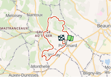
Pommard Autour de Pommard et Volnay page 119

grasgilbert
User

Length
13.5 km

Max alt
394 m

Uphill gradient
307 m
Km-Effort
17.6 km

Min alt
247 m

Downhill gradient
306 m
Boucle
Yes
Creation date :
2024-10-17 11:42:45.681
Updated on :
2024-10-17 17:01:08.687
4h00
Difficulty : Difficult

FREE GPS app for hiking
 SityTrail
IGN / Geographical institutes
SityTrail Plus
The world is yours!
About
Trail Walking of 13.5 km to be discovered at Bourgogne-Franche-Comté, Côte-d'Or, Pommard. This trail is proposed by grasgilbert.
Positioning
Country:
France
Region :
Bourgogne-Franche-Comté
Department/Province :
Côte-d'Or
Municipality :
Pommard
Location:
Unknown
Start:(Dec)
Start:(UTM)
636420 ; 5207751 (31T) N.
Comments