


Thenailles

mjh
User
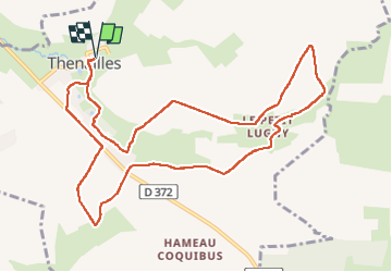

Length
11.1 km

Max alt
196 m

Uphill gradient
158 m
Km-Effort
13.2 km

Min alt
141 m

Downhill gradient
158 m
Boucle
Yes
Creation date :
2024-10-20 10:01:33.863
Updated on :
2024-10-20 12:43:24.706
2h36
Difficulty : Easy

FREE GPS app for hiking
 SityTrail
IGN / Geographical institutes
SityTrail Plus
The world is yours!
About
Trail Walking of 11.1 km to be discovered at Hauts-de-France, Aisne, Thenailles. This trail is proposed by mjh.
Positioning
Country:
France
Region :
Hauts-de-France
Department/Province :
Aisne
Municipality :
Thenailles
Location:
Unknown
Start:(Dec)
Start:(UTM)
567734 ; 5519180 (31U) N.
Comments