


Boucle Reculet Crêt de la Neige

Jean-Paulchoux
User
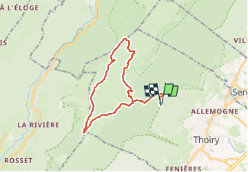

Length
14.9 km

Max alt
1707 m

Uphill gradient
1013 m
Km-Effort
28 km

Min alt
863 m

Downhill gradient
1013 m
Boucle
Yes
Creation date :
2024-10-20 07:20:17.266
Updated on :
2024-10-20 14:34:05.243
5h02
Difficulty : Difficult

FREE GPS app for hiking
 SityTrail
IGN / Geographical institutes
SityTrail Plus
The world is yours!
About
Trail Walking of 14.9 km to be discovered at Auvergne-Rhône-Alpes, Ain, Thoiry. This trail is proposed by Jean-Paulchoux.
Positioning
Country:
France
Region :
Auvergne-Rhône-Alpes
Department/Province :
Ain
Municipality :
Thoiry
Location:
Unknown
Start:(Dec)
Start:(UTM)
728020 ; 5125851 (31T) N.
Comments