


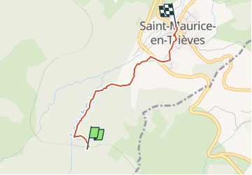
Chanterelles ST MAURICE

RD78-38
User

Length
2.1 km

Max alt
1041 m

Uphill gradient
1 m
Km-Effort
2.8 km

Min alt
838 m

Downhill gradient
198 m
Boucle
No
Creation date :
2024-10-20 14:31:30.0
Updated on :
2024-10-20 14:56:51.454
19m
Difficulty : Easy

FREE GPS app for hiking
 SityTrail
IGN / Geographical institutes
SityTrail Plus
The world is yours!
About
Trail Walking of 2.1 km to be discovered at Auvergne-Rhône-Alpes, Isère, Saint-Maurice-en-Trièves. This trail is proposed by RD78-38.
Description
Cueillette Chanterelles, sanguins et pieds de mouton
Positioning
Country:
France
Region :
Auvergne-Rhône-Alpes
Department/Province :
Isère
Municipality :
Saint-Maurice-en-Trièves
Location:
Unknown
Start:(Dec)
Start:(UTM)
709970 ; 4959083 (31T) N.
Comments