


privas

raygautier
User
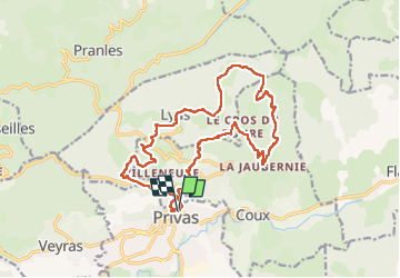

Length
19.8 km

Max alt
675 m

Uphill gradient
809 m
Km-Effort
31 km

Min alt
238 m

Downhill gradient
808 m
Boucle
Yes
Creation date :
2024-10-20 06:13:41.103
Updated on :
2024-10-20 17:48:00.511
8h51
Difficulty : Very difficult

FREE GPS app for hiking
 SityTrail
IGN / Geographical institutes
SityTrail Plus
The world is yours!
About
Trail Walking of 19.8 km to be discovered at Auvergne-Rhône-Alpes, Ardèche, Privas. This trail is proposed by raygautier.
Positioning
Country:
France
Region :
Auvergne-Rhône-Alpes
Department/Province :
Ardèche
Municipality :
Privas
Location:
Unknown
Start:(Dec)
Start:(UTM)
626631 ; 4954926 (31T) N.
Comments