


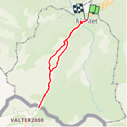
66-Mantet-Porteille de Mentet 17/05/2015*

Jovila
User


5h48
Difficulty : Difficult

FREE GPS app for hiking
 SityTrail
IGN / Geographical institutes
SityTrail Plus
The world is yours!
About
Trail Walking of 15.3 km to be discovered at Occitania, Pyrénées-Orientales, Mantet. This trail is proposed by Jovila.
Description
Temps mis avec les arrêts : 7h25.
Départ du parking à l'entrée du Village de Mantet.
Se retourner de temps en temps dans les montées pour admirer Mantet.
Le chemin du retour à partir de la baraque des allemands n'est pas très joli (sous bois). Reprendre plutôt le chemin de l'allée, ou prendre un autre itinéraire.
Positioning
Comments