


mont noir

dehemjacques
User
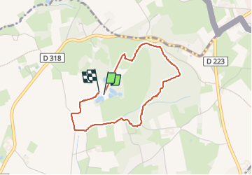

Length
3 km

Max alt
141 m

Uphill gradient
99 m
Km-Effort
4.3 km

Min alt
37 m

Downhill gradient
105 m
Boucle
Yes
Creation date :
2024-10-23 11:32:12.515
Updated on :
2024-10-23 12:31:41.612
47m
Difficulty : Easy

FREE GPS app for hiking
 SityTrail
IGN / Geographical institutes
SityTrail Plus
The world is yours!
About
Trail Walking of 3 km to be discovered at Hauts-de-France, Nord, Saint-Jans-Cappel. This trail is proposed by dehemjacques.
Positioning
Country:
France
Region :
Hauts-de-France
Department/Province :
Nord
Municipality :
Saint-Jans-Cappel
Location:
Unknown
Start:(Dec)
Start:(UTM)
480569 ; 5624926 (31U) N.
Comments