


PEGROS/CABASSE/LA GARONETTE/DAVID

Michel DUBOIS
User

Length
13.4 km

Max alt
341 m

Uphill gradient
552 m
Km-Effort
21 km

Min alt
18 m

Downhill gradient
552 m
Boucle
Yes
Creation date :
2024-10-23 15:39:43.232
Updated on :
2024-10-23 15:44:51.269
4h43
Difficulty : Medium

FREE GPS app for hiking
 SityTrail
IGN / Geographical institutes
SityTrail Plus
The world is yours!
About
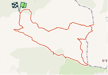
Trail Walking of 13.4 km to be discovered at Provence-Alpes-Côte d'Azur, Var, Sainte-Maxime. This trail is proposed by Michel DUBOIS.
Description
Au col de gratteloup, prendre la petite route à gauche jusqu'au col de Pegros (statonnement)
Positioning
Country:
France
Region :
Provence-Alpes-Côte d'Azur
Department/Province :
Var
Municipality :
Sainte-Maxime
Location:
Unknown
Start:(Dec)
Start:(UTM)
307256 ; 4804236 (32T) N.
Comments