


Ourches Cobonne col croix Bezot

alinetpierre
User
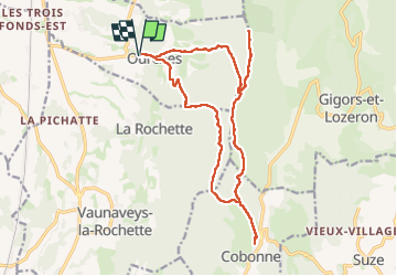

Length
18.8 km

Max alt
990 m

Uphill gradient
960 m
Km-Effort
32 km

Min alt
336 m

Downhill gradient
960 m
Boucle
Yes
Creation date :
2024-10-24 06:37:21.0
Updated on :
2024-10-24 13:38:00.443

FREE GPS app for hiking
 SityTrail
IGN / Geographical institutes
SityTrail Plus
The world is yours!
About
Trail of 18.8 km to be discovered at Auvergne-Rhône-Alpes, Drôme, Ourches. This trail is proposed by alinetpierre.
Description
Très belle randonnée d’automne
Photos


Positioning
Country:
France
Region :
Auvergne-Rhône-Alpes
Department/Province :
Drôme
Municipality :
Ourches
Location:
Unknown
Start:(Dec)
Start:(UTM)
661429 ; 4963286 (31T) N.
Comments