


20241024-barentin

doudet
User

Length
13.4 km

Max alt
120 m

Uphill gradient
178 m
Km-Effort
15.8 km

Min alt
19 m

Downhill gradient
178 m
Boucle
Yes
Creation date :
2024-10-24 11:56:06.985
Updated on :
2024-10-25 06:27:16.919
3h39
Difficulty : Medium

FREE GPS app for hiking
 SityTrail
IGN / Geographical institutes
SityTrail Plus
The world is yours!
About
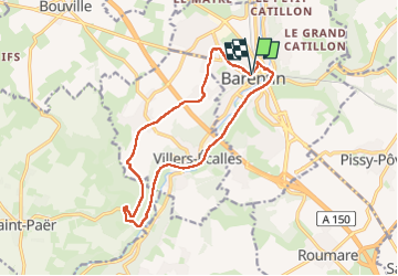
Trail Walking of 13.4 km to be discovered at Normandy, Seine-Maritime, Barentin. This trail is proposed by doudet.
Description
Boucle A-R au départ de l'Eglise St Martin
Positioning
Country:
France
Region :
Normandy
Department/Province :
Seine-Maritime
Municipality :
Barentin
Location:
Unknown
Start:(Dec)
Start:(UTM)
351848 ; 5490249 (31U) N.
Comments