


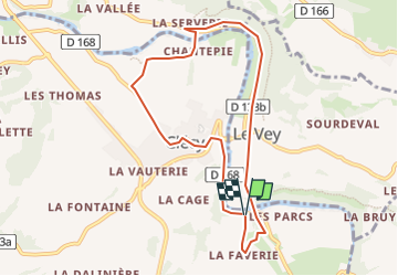
Clécy le vey

semaine
User

Length
7.8 km

Max alt
80 m

Uphill gradient
156 m
Km-Effort
9.9 km

Min alt
33 m

Downhill gradient
160 m
Boucle
Yes
Creation date :
2024-10-24 16:14:17.991
Updated on :
2024-10-24 16:15:08.429
2h14
Difficulty : Medium

FREE GPS app for hiking
 SityTrail
IGN / Geographical institutes
SityTrail Plus
The world is yours!
About
Trail Walking of 7.8 km to be discovered at Normandy, Calvados, Clécy. This trail is proposed by semaine.
Positioning
Country:
France
Region :
Normandy
Department/Province :
Calvados
Municipality :
Clécy
Location:
Unknown
Start:(Dec)
Start:(UTM)
685175 ; 5420386 (30U) N.
Comments