


Meloisey par monts et par vers page 118

grasgilbert
User
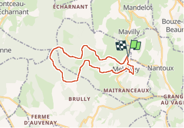

Length
14 km

Max alt
550 m

Uphill gradient
336 m
Km-Effort
18.4 km

Min alt
372 m

Downhill gradient
332 m
Boucle
Yes
Creation date :
2024-10-24 11:47:37.454
Updated on :
2024-10-24 17:20:03.72
4h11
Difficulty : Difficult

FREE GPS app for hiking
 SityTrail
IGN / Geographical institutes
SityTrail Plus
The world is yours!
About
Trail Walking of 14 km to be discovered at Bourgogne-Franche-Comté, Côte-d'Or, Meloisey. This trail is proposed by grasgilbert.
Positioning
Country:
France
Region :
Bourgogne-Franche-Comté
Department/Province :
Côte-d'Or
Municipality :
Meloisey
Location:
Unknown
Start:(Dec)
Start:(UTM)
632030 ; 5210779 (31T) N.
Comments