


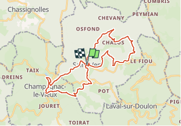
saint vert chalus champagnac le vieux 20km 815m dénivelé

jeanic63
User

Length
19 km

Max alt
1108 m

Uphill gradient
812 m
Km-Effort
30 km

Min alt
758 m

Downhill gradient
814 m
Boucle
Yes
Creation date :
2024-10-25 15:22:20.224
Updated on :
2024-11-04 19:59:57.694
6h47
Difficulty : Medium

FREE GPS app for hiking
 SityTrail
IGN / Geographical institutes
SityTrail Plus
The world is yours!
About
Trail On foot of 19 km to be discovered at Auvergne-Rhône-Alpes, Haute-Loire, Saint-Vert. This trail is proposed by jeanic63.
Description
départ village de saint vert haute loire
Positioning
Country:
France
Region :
Auvergne-Rhône-Alpes
Department/Province :
Haute-Loire
Municipality :
Saint-Vert
Location:
Unknown
Start:(Dec)
Start:(UTM)
541651 ; 5024320 (31T) N.
Comments