


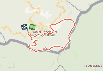
autour de St Martin l'albere et puig forcadell

stef789
User GUIDE

Length
10.3 km

Max alt
974 m

Uphill gradient
464 m
Km-Effort
16.5 km

Min alt
522 m

Downhill gradient
467 m
Boucle
Yes
Creation date :
2024-10-25 11:38:50.374
Updated on :
2024-10-25 16:39:07.397
4h59
Difficulty : Difficult

FREE GPS app for hiking
 SityTrail
IGN / Geographical institutes
SityTrail Plus
The world is yours!
About
Trail Walking of 10.3 km to be discovered at Occitania, Pyrénées-Orientales, L'Albère. This trail is proposed by stef789.
Photos


29 photos in total. Please click on a photo to see them all in the gallery.
Positioning
Country:
France
Region :
Occitania
Department/Province :
Pyrénées-Orientales
Municipality :
L'Albère
Location:
Unknown
Start:(Dec)
Start:(UTM)
491811 ; 4701406 (31T) N.
Comments