


GPX Download: Excursion gourmande 16 : "Les sommets de la Warche" Xhoffraix - Randonner dans les Cantons de l'Est

Efr
User
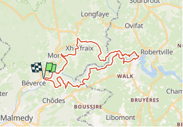

Length
16.9 km

Max alt
522 m

Uphill gradient
476 m
Km-Effort
23 km

Min alt
353 m

Downhill gradient
479 m
Boucle
Yes
Creation date :
2024-10-25 19:02:00.995
Updated on :
2024-10-28 14:03:26.659
5h17
Difficulty : Very difficult

FREE GPS app for hiking
 SityTrail
IGN / Geographical institutes
SityTrail Plus
The world is yours!
About
Trail Walking of 16.9 km to be discovered at Wallonia, Liège, Malmedy. This trail is proposed by Efr.
Description
Depart: Rte de la Valée (Taverne au moulin)
Malmedy
Positioning
Country:
Belgium
Region :
Wallonia
Department/Province :
Liège
Municipality :
Malmedy
Location:
Unknown
Start:(Dec)
Start:(UTM)
290283 ; 5592093 (32U) N.
Comments
Super