


20150521-tostes

doudet
User

Length
12.3 km

Max alt
135 m

Uphill gradient
191 m
Km-Effort
14.8 km

Min alt
49 m

Downhill gradient
157 m
Boucle
No
Creation date :
2018-09-11 09:12:16.375
Updated on :
2018-09-11 09:12:16.375
3h13
Difficulty : Easy

FREE GPS app for hiking
 SityTrail
IGN / Geographical institutes
SityTrail Plus
The world is yours!
About
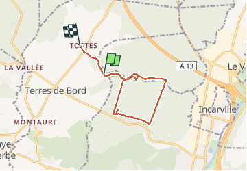
Trail Walking of 12.3 km to be discovered at Normandy, Eure, Terres de Bord. This trail is proposed by doudet.
Description
Boucle A-R au départ de l'Eglise de Tostes
Photos


Positioning
Country:
France
Region :
Normandy
Department/Province :
Eure
Municipality :
Terres de Bord
Location:
Tostes
Start:(Dec)
Start:(UTM)
363329 ; 5456984 (31U) N.
Comments