


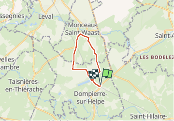
Dompierre sur helpe vers Monceau

mjh
User

Length
7.5 km

Max alt
180 m

Uphill gradient
62 m
Km-Effort
8.3 km

Min alt
138 m

Downhill gradient
62 m
Boucle
Yes
Creation date :
2024-10-27 12:24:02.565
Updated on :
2024-10-27 14:21:25.96
1h52
Difficulty : Easy

FREE GPS app for hiking
 SityTrail
IGN / Geographical institutes
SityTrail Plus
The world is yours!
About
Trail Walking of 7.5 km to be discovered at Hauts-de-France, Nord, Dompierre-sur-Helpe. This trail is proposed by mjh.
Photos

Positioning
Country:
France
Region :
Hauts-de-France
Department/Province :
Nord
Municipality :
Dompierre-sur-Helpe
Location:
Unknown
Start:(Dec)
Start:(UTM)
562175 ; 5555433 (31U) N.
Comments