


J2 Molines en Queyras Sommet Bucher

Monjean
User
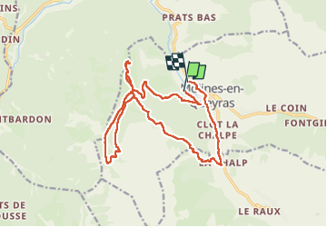

Length
19.6 km

Max alt
2280 m

Uphill gradient
861 m
Km-Effort
31 km

Min alt
1709 m

Downhill gradient
878 m
Boucle
No
Creation date :
2024-10-28 07:46:48.962
Updated on :
2024-11-05 16:36:39.544
7h42
Difficulty : Very difficult

FREE GPS app for hiking
 SityTrail
IGN / Geographical institutes
SityTrail Plus
The world is yours!
About
Trail Walking of 19.6 km to be discovered at Provence-Alpes-Côte d'Azur, Hautes-Alpes, Molines-en-Queyras. This trail is proposed by Monjean.
Positioning
Country:
France
Region :
Provence-Alpes-Côte d'Azur
Department/Province :
Hautes-Alpes
Municipality :
Molines-en-Queyras
Location:
Unknown
Start:(Dec)
Start:(UTM)
328483 ; 4955358 (32T) N.
Comments