


Tour des cols sare

tine60
User
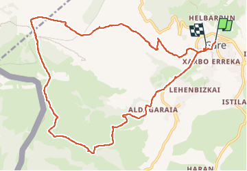

Length
13.2 km

Max alt
714 m

Uphill gradient
699 m
Km-Effort
22 km

Min alt
57 m

Downhill gradient
694 m
Boucle
No
Creation date :
2024-10-29 08:31:28.0
Updated on :
2024-10-29 14:16:29.572

FREE GPS app for hiking
 SityTrail
IGN / Geographical institutes
SityTrail Plus
The world is yours!
About
Trail of 13.2 km to be discovered at New Aquitaine, Pyrénées-Atlantiques, Sare. This trail is proposed by tine60.
Positioning
Country:
France
Region :
New Aquitaine
Department/Province :
Pyrénées-Atlantiques
Municipality :
Sare
Location:
Unknown
Start:(Dec)
Start:(UTM)
615189 ; 4796637 (30T) N.
Comments