


Sainte croix de caderne

labarone
User

Length
19.4 km

Max alt
811 m

Uphill gradient
793 m
Km-Effort
30 km

Min alt
338 m

Downhill gradient
787 m
Boucle
Yes
Creation date :
2024-10-29 07:54:06.847
Updated on :
2024-10-29 15:50:35.98
7h11
Difficulty : Difficult

FREE GPS app for hiking
 SityTrail
IGN / Geographical institutes
SityTrail Plus
The world is yours!
About
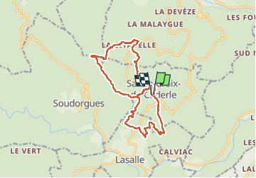
Trail Walking of 19.4 km to be discovered at Occitania, Gard, Sainte-Croix-de-Caderle. This trail is proposed by labarone.
Description
des passages montée ds roches hard mais descentes hard
fin de parcours une chapelle à voir
Photos


Positioning
Country:
France
Region :
Occitania
Department/Province :
Gard
Municipality :
Sainte-Croix-de-Caderle
Location:
Unknown
Start:(Dec)
Start:(UTM)
569293 ; 4879756 (31T) N.
Comments