


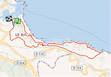
raccou - plage de l'ouillet par terre, retour par sentier littoral

stef789
User GUIDE

Length
5.9 km

Max alt
31 m

Uphill gradient
85 m
Km-Effort
7.1 km

Min alt
-1 m

Downhill gradient
88 m
Boucle
Yes
Creation date :
2024-10-29 14:35:29.42
Updated on :
2024-10-29 16:22:23.656
1h46
Difficulty : Very easy

FREE GPS app for hiking
 SityTrail
IGN / Geographical institutes
SityTrail Plus
The world is yours!
About
Trail Walking of 5.9 km to be discovered at Occitania, Pyrénées-Orientales, Argelès-sur-Mer. This trail is proposed by stef789.
Photos


23 photos in total. Please click on a photo to see them all in the gallery.
Positioning
Country:
France
Region :
Occitania
Department/Province :
Pyrénées-Orientales
Municipality :
Argelès-sur-Mer
Location:
Unknown
Start:(Dec)
Start:(UTM)
504224 ; 4709579 (31T) N.
Comments