


marcieu (rouac)- roubanis

maupassant38
User
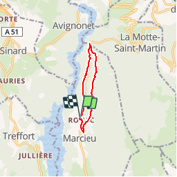

Length
7.7 km

Max alt
916 m

Uphill gradient
303 m
Km-Effort
11.8 km

Min alt
651 m

Downhill gradient
305 m
Boucle
Yes
Creation date :
2019-02-22 22:31:37.756
Updated on :
2019-02-22 22:31:37.765
2h40
Difficulty : Easy

FREE GPS app for hiking
 SityTrail
IGN / Geographical institutes
SityTrail Plus
The world is yours!
About
Trail Walking of 7.7 km to be discovered at Auvergne-Rhône-Alpes, Isère, Marcieu. This trail is proposed by maupassant38.
Positioning
Country:
France
Region :
Auvergne-Rhône-Alpes
Department/Province :
Isère
Municipality :
Marcieu
Location:
Unknown
Start:(Dec)
Start:(UTM)
712242 ; 4977817 (31T) N.
Comments