


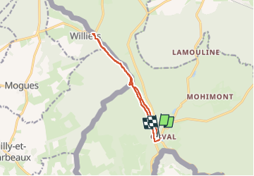
orval

jcb48
User

Length
9.8 km

Max alt
273 m

Uphill gradient
157 m
Km-Effort
11.8 km

Min alt
204 m

Downhill gradient
155 m
Boucle
Yes
Creation date :
2024-10-31 13:20:00.822
Updated on :
2024-10-31 16:12:58.257
2h52
Difficulty : Medium

FREE GPS app for hiking
 SityTrail
IGN / Geographical institutes
SityTrail Plus
The world is yours!
About
Trail Walking of 9.8 km to be discovered at Wallonia, Luxembourg, Florenville. This trail is proposed by jcb48.
Description
marche
Positioning
Country:
Belgium
Region :
Wallonia
Department/Province :
Luxembourg
Municipality :
Florenville
Location:
Villers-devant-Orval
Start:(Dec)
Start:(UTM)
669281 ; 5500764 (31U) N.
Comments