


mullerthal e1

thomas1986
User

Length
14.6 km

Max alt
344 m

Uphill gradient
362 m
Km-Effort
19.4 km

Min alt
161 m

Downhill gradient
362 m
Boucle
Yes
Creation date :
2024-11-01 09:50:20.973
Updated on :
2024-11-01 14:04:26.816
3h32
Difficulty : Medium

FREE GPS app for hiking
 SityTrail
IGN / Geographical institutes
SityTrail Plus
The world is yours!
About
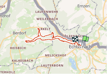
Trail Walking of 14.6 km to be discovered at Unknown, Canton Echternach, Echternach. This trail is proposed by thomas1986.
Photos


34 photos in total. Please click on a photo to see them all in the gallery.
Positioning
Country:
Luxembourg
Region :
Unknown
Department/Province :
Canton Echternach
Municipality :
Echternach
Location:
Unknown
Start:(Dec)
Start:(UTM)
314596 ; 5521020 (32U) N.
Comments