


escoulin

raygautier
User
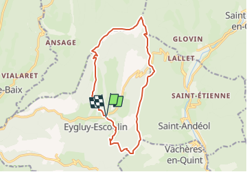

Length
14.9 km

Max alt
1317 m

Uphill gradient
1069 m
Km-Effort
29 km

Min alt
513 m

Downhill gradient
1063 m
Boucle
Yes
Creation date :
2024-11-02 19:16:21.859
Updated on :
2024-11-02 19:17:16.009
6h36
Difficulty : Very difficult

FREE GPS app for hiking
 SityTrail
IGN / Geographical institutes
SityTrail Plus
The world is yours!
About
Trail Walking of 14.9 km to be discovered at Auvergne-Rhône-Alpes, Drôme, Eygluy-Escoulin. This trail is proposed by raygautier.
Description
tres belle tres difficile
Positioning
Country:
France
Region :
Auvergne-Rhône-Alpes
Department/Province :
Drôme
Municipality :
Eygluy-Escoulin
Location:
Unknown
Start:(Dec)
Start:(UTM)
675627 ; 4963479 (31T) N.
Comments