


CHAUVIGNÉ-LA GENNERIE 6,7km JY

COGLAIS3
User
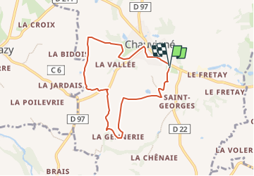

Length
6.7 km

Max alt
95 m

Uphill gradient
60 m
Km-Effort
7.5 km

Min alt
63 m

Downhill gradient
65 m
Boucle
Yes
Creation date :
2024-11-02 19:53:13.841
Updated on :
2024-11-02 19:55:10.586
0m
Difficulty : Very easy

FREE GPS app for hiking
 SityTrail
IGN / Geographical institutes
SityTrail Plus
The world is yours!
About
Trail Nordic walking of 6.7 km to be discovered at Brittany, Ille-et-Vilaine, Chauvigné. This trail is proposed by COGLAIS3.
Positioning
Country:
France
Region :
Brittany
Department/Province :
Ille-et-Vilaine
Municipality :
Chauvigné
Location:
Unknown
Start:(Dec)
Start:(UTM)
614408 ; 5358909 (30U) N.
Comments