


mourre negre

ysst
User
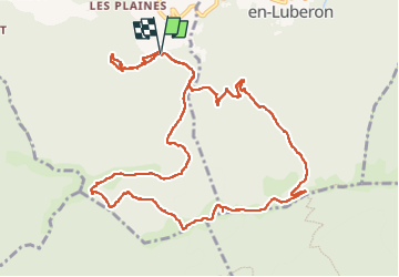

Length
13.7 km

Max alt
1122 m

Uphill gradient
887 m
Km-Effort
26 km

Min alt
587 m

Downhill gradient
884 m
Boucle
Yes
Creation date :
2024-10-21 07:19:28.22
Updated on :
2024-11-03 10:30:51.775
5h43
Difficulty : Medium

FREE GPS app for hiking
 SityTrail
IGN / Geographical institutes
SityTrail Plus
The world is yours!
About
Trail Walking of 13.7 km to be discovered at Provence-Alpes-Côte d'Azur, Vaucluse, Auribeau. This trail is proposed by ysst.
Description
mourre nègre
Positioning
Country:
France
Region :
Provence-Alpes-Côte d'Azur
Department/Province :
Vaucluse
Municipality :
Auribeau
Location:
Unknown
Start:(Dec)
Start:(UTM)
697617 ; 4856264 (31T) N.
Comments