


St cirq limogne calvignac

Glurps
User
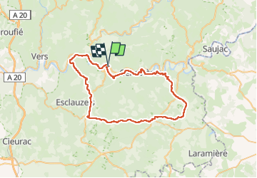

Length
58 km

Max alt
385 m

Uphill gradient
1021 m
Km-Effort
72 km

Min alt
130 m

Downhill gradient
1030 m
Boucle
No
Creation date :
2024-11-03 09:44:07.0
Updated on :
2024-11-03 15:15:46.572

FREE GPS app for hiking
 SityTrail
IGN / Geographical institutes
SityTrail Plus
The world is yours!
About
Trail of 58 km to be discovered at Occitania, Lot, Tour-de-Faure. This trail is proposed by Glurps.
Positioning
Country:
France
Region :
Occitania
Department/Province :
Lot
Municipality :
Tour-de-Faure
Location:
Unknown
Start:(Dec)
Start:(UTM)
395332 ; 4925174 (31T) N.
Comments