


CHAUVIGNE-ROMAZY-RIMOU 16km JY

COGLAIS3
User
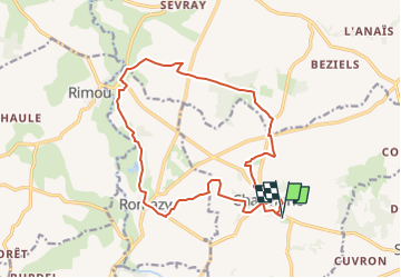

Length
16.5 km

Max alt
99 m

Uphill gradient
172 m
Km-Effort
18.8 km

Min alt
21 m

Downhill gradient
173 m
Boucle
Yes
Creation date :
2024-11-03 16:09:14.728
Updated on :
2024-11-03 16:10:16.978
0m
Difficulty : Easy

FREE GPS app for hiking
 SityTrail
IGN / Geographical institutes
SityTrail Plus
The world is yours!
About
Trail Nordic walking of 16.5 km to be discovered at Brittany, Ille-et-Vilaine, Chauvigné. This trail is proposed by COGLAIS3.
Positioning
Country:
France
Region :
Brittany
Department/Province :
Ille-et-Vilaine
Municipality :
Chauvigné
Location:
Unknown
Start:(Dec)
Start:(UTM)
614406 ; 5358950 (30U) N.
Comments