


le MARTRAT modifiée

patourad
User
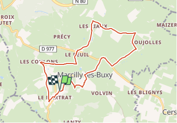

Length
8.9 km

Max alt
383 m

Uphill gradient
182 m
Km-Effort
11.4 km

Min alt
285 m

Downhill gradient
183 m
Boucle
Yes
Creation date :
2024-11-04 16:29:13.255
Updated on :
2024-11-04 16:30:32.203
2h34
Difficulty : Medium

FREE GPS app for hiking
 SityTrail
IGN / Geographical institutes
SityTrail Plus
The world is yours!
About
Trail Walking of 8.9 km to be discovered at Bourgogne-Franche-Comté, Saône-et-Loire, Marcilly-lès-Buxy. This trail is proposed by patourad.
Positioning
Country:
France
Region :
Bourgogne-Franche-Comté
Department/Province :
Saône-et-Loire
Municipality :
Marcilly-lès-Buxy
Location:
Unknown
Start:(Dec)
Start:(UTM)
621299 ; 5174690 (31T) N.
Comments