


chanturgue le puy de var tremonteix

jeanic63
User
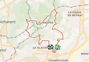

Length
10.3 km

Max alt
607 m

Uphill gradient
396 m
Km-Effort
15.6 km

Min alt
387 m

Downhill gradient
395 m
Boucle
Yes
Creation date :
2024-11-04 20:18:04.309
Updated on :
2024-11-07 17:46:36.179
3h32
Difficulty : Easy

FREE GPS app for hiking
 SityTrail
IGN / Geographical institutes
SityTrail Plus
The world is yours!
About
Trail On foot of 10.3 km to be discovered at Auvergne-Rhône-Alpes, Puy-de-Dôme, Clermont-Ferrand. This trail is proposed by jeanic63.
Description
départ angle rue lécuellé bd Charcot
Positioning
Country:
France
Region :
Auvergne-Rhône-Alpes
Department/Province :
Puy-de-Dôme
Municipality :
Clermont-Ferrand
Location:
Unknown
Start:(Dec)
Start:(UTM)
506922 ; 5071147 (31T) N.
Comments