


Rando. Babas

Tommy Eric
User

Length
6.7 km

Max alt
370 m

Uphill gradient
64 m
Km-Effort
7.6 km

Min alt
337 m

Downhill gradient
86 m
Boucle
No
Creation date :
2024-11-06 13:19:30.775
Updated on :
2024-11-06 15:12:07.841
1h52
Difficulty : Medium

FREE GPS app for hiking
 SityTrail
IGN / Geographical institutes
SityTrail Plus
The world is yours!
About
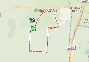
Trail Walking of 6.7 km to be discovered at Grand Est, Ardennes, Sévigny-la-Forêt. This trail is proposed by Tommy Eric.
Description
Sévigny la Forêt
Positioning
Country:
France
Region :
Grand Est
Department/Province :
Ardennes
Municipality :
Sévigny-la-Forêt
Location:
Unknown
Start:(Dec)
Start:(UTM)
606495 ; 5526018 (31U) N.
Comments