


Montaigues

Dupuybadonniere
User

Length
15.4 km

Max alt
253 m

Uphill gradient
228 m
Km-Effort
18.4 km

Min alt
136 m

Downhill gradient
229 m
Boucle
Yes
Creation date :
2024-10-20 07:37:29.195
Updated on :
2024-11-08 12:13:04.455
4h09
Difficulty : Difficult

FREE GPS app for hiking
 SityTrail
IGN / Geographical institutes
SityTrail Plus
The world is yours!
About
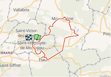
Trail Walking of 15.4 km to be discovered at Occitania, Gard, Saint-Hippolyte-de-Montaigu. This trail is proposed by Dupuybadonniere.
Positioning
Country:
France
Region :
Occitania
Department/Province :
Gard
Municipality :
Saint-Hippolyte-de-Montaigu
Location:
Unknown
Start:(Dec)
Start:(UTM)
619590 ; 4876634 (31T) N.
Comments