


St Brice

Dupuybadonniere
User
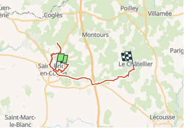

Length
21 km

Max alt
174 m

Uphill gradient
278 m
Km-Effort
24 km

Min alt
91 m

Downhill gradient
215 m
Boucle
No
Creation date :
2024-11-08 08:46:30.238
Updated on :
2024-11-08 12:13:08.11
2h45
Difficulty : Very easy

FREE GPS app for hiking
 SityTrail
IGN / Geographical institutes
SityTrail Plus
The world is yours!
About
Trail Walking of 21 km to be discovered at Brittany, Ille-et-Vilaine, Maen-Roch. This trail is proposed by Dupuybadonniere.
Positioning
Country:
France
Region :
Brittany
Department/Province :
Ille-et-Vilaine
Municipality :
Maen-Roch
Location:
Saint-Brice-en-Coglès
Start:(Dec)
Start:(UTM)
621263 ; 5363177 (30U) N.
Comments