


la rippe variante

pierrounet
User
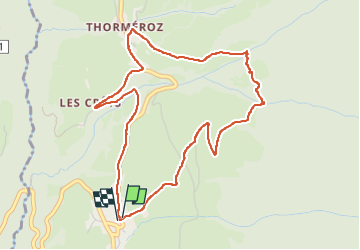

Length
5.2 km

Max alt
842 m

Uphill gradient
210 m
Km-Effort
8 km

Min alt
641 m

Downhill gradient
208 m
Boucle
Yes
Creation date :
2024-11-08 11:48:06.312
Updated on :
2024-11-08 14:51:23.542
2h07
Difficulty : Medium

FREE GPS app for hiking
 SityTrail
IGN / Geographical institutes
SityTrail Plus
The world is yours!
About
Trail Walking of 5.2 km to be discovered at Auvergne-Rhône-Alpes, Savoy, Thoiry. This trail is proposed by pierrounet.
Positioning
Country:
France
Region :
Auvergne-Rhône-Alpes
Department/Province :
Savoy
Municipality :
Thoiry
Location:
Unknown
Start:(Dec)
Start:(UTM)
268312 ; 5052793 (32T) N.
Comments