


Étang Basouche

Dupuybadonniere
User
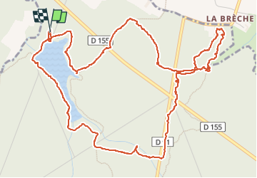

Length
7.4 km

Max alt
128 m

Uphill gradient
100 m
Km-Effort
8.8 km

Min alt
82 m

Downhill gradient
99 m
Boucle
Yes
Creation date :
2024-11-09 08:40:15.837
Updated on :
2024-11-09 11:18:14.673
1h57
Difficulty : Very easy

FREE GPS app for hiking
 SityTrail
IGN / Geographical institutes
SityTrail Plus
The world is yours!
About
Trail Walking of 7.4 km to be discovered at Brittany, Ille-et-Vilaine, Bazouges-la-Pérouse. This trail is proposed by Dupuybadonniere.
Positioning
Country:
France
Region :
Brittany
Department/Province :
Ille-et-Vilaine
Municipality :
Bazouges-la-Pérouse
Location:
Unknown
Start:(Dec)
Start:(UTM)
605846 ; 5371127 (30U) N.
Comments