


Saint Wandrille matin

RC76
User
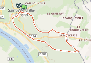

Length
9.2 km

Max alt
131 m

Uphill gradient
159 m
Km-Effort
11.3 km

Min alt
17 m

Downhill gradient
162 m
Boucle
Yes
Creation date :
2024-11-09 08:26:30.0
Updated on :
2024-11-09 22:50:06.756
2h41
Difficulty : Medium

FREE GPS app for hiking
 SityTrail
IGN / Geographical institutes
SityTrail Plus
The world is yours!
About
Trail Walking of 9.2 km to be discovered at Normandy, Seine-Maritime, Rives-en-Seine. This trail is proposed by RC76.
Positioning
Country:
France
Region :
Normandy
Department/Province :
Seine-Maritime
Municipality :
Rives-en-Seine
Location:
Unknown
Start:(Dec)
Start:(UTM)
338380 ; 5488477 (31U) N.
Comments