


Reco Ch JY 3km

COGLAIS3
User
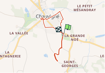

Length
3.4 km

Max alt
95 m

Uphill gradient
26 m
Km-Effort
3.7 km

Min alt
81 m

Downhill gradient
21 m
Boucle
Yes
Creation date :
2024-11-09 18:49:22.555
Updated on :
2024-11-09 20:50:54.583
0m
Difficulty : Very easy

FREE GPS app for hiking
 SityTrail
IGN / Geographical institutes
SityTrail Plus
The world is yours!
About
Trail Nordic walking of 3.4 km to be discovered at Brittany, Ille-et-Vilaine, Chauvigné. This trail is proposed by COGLAIS3.
Positioning
Country:
France
Region :
Brittany
Department/Province :
Ille-et-Vilaine
Municipality :
Chauvigné
Location:
Unknown
Start:(Dec)
Start:(UTM)
614417 ; 5358962 (30U) N.
Comments