


10/11/24 - Aubure

delm
User
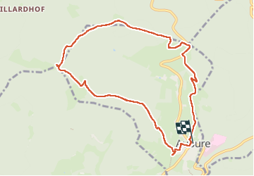

Length
9.6 km

Max alt
1143 m

Uphill gradient
429 m
Km-Effort
15.3 km

Min alt
737 m

Downhill gradient
430 m
Boucle
Yes
Creation date :
2024-11-10 10:54:32.0
Updated on :
2024-11-10 14:53:55.295

FREE GPS app for hiking
 SityTrail
IGN / Geographical institutes
SityTrail Plus
The world is yours!
About
Trail of 9.6 km to be discovered at Grand Est, Haut-Rhin, Aubure. This trail is proposed by delm.
Description
Agréable randonnée avec de belles vue
Positioning
Country:
France
Region :
Grand Est
Department/Province :
Haut-Rhin
Municipality :
Aubure
Location:
Unknown
Start:(Dec)
Start:(UTM)
367875 ; 5339784 (32U) N.
Comments