


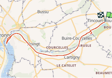
Tincourt boucly /Péronne

Ty Mrlt
User

Length
21 km

Max alt
68 m

Uphill gradient
134 m
Km-Effort
23 km

Min alt
47 m

Downhill gradient
134 m
Boucle
Yes
Creation date :
2024-11-10 11:16:37.799
Updated on :
2024-11-10 15:51:37.66
4h34
Difficulty : Medium

FREE GPS app for hiking
 SityTrail
IGN / Geographical institutes
SityTrail Plus
The world is yours!
About
Trail Walking of 21 km to be discovered at Hauts-de-France, Somme, Tincourt-Boucly. This trail is proposed by Ty Mrlt.
Positioning
Country:
France
Region :
Hauts-de-France
Department/Province :
Somme
Municipality :
Tincourt-Boucly
Location:
Unknown
Start:(Dec)
Start:(UTM)
503258 ; 5531767 (31U) N.
Comments