


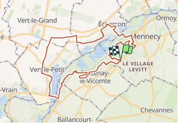
Mennecy VTT

godmer
User

Length
20 km

Max alt
88 m

Uphill gradient
212 m
Km-Effort
23 km

Min alt
44 m

Downhill gradient
213 m
Boucle
Yes
Creation date :
2024-11-11 10:48:52.947
Updated on :
2025-06-20 15:38:22.21
1h34
Difficulty : Medium

FREE GPS app for hiking
 SityTrail
IGN / Geographical institutes
SityTrail Plus
The world is yours!
About
Trail Mountain bike of 20 km to be discovered at Ile-de-France, Essonne, Mennecy. This trail is proposed by godmer.
Positioning
Country:
France
Region :
Ile-de-France
Department/Province :
Essonne
Municipality :
Mennecy
Location:
Unknown
Start:(Dec)
Start:(UTM)
457022 ; 5378205 (31U) N.
Comments