


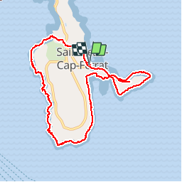
Tour St Jean Cap Ferrat

ja.13061965
User

Length
10.8 km

Max alt
47 m

Uphill gradient
218 m
Km-Effort
13.7 km

Min alt
-1 m

Downhill gradient
217 m
Boucle
Yes
Creation date :
2019-06-20 09:32:47.048
Updated on :
2019-06-20 09:32:47.56
4h53
Difficulty : Very easy

FREE GPS app for hiking
 SityTrail
IGN / Geographical institutes
SityTrail Plus
The world is yours!
About
Trail Walking of 10.8 km to be discovered at Provence-Alpes-Côte d'Azur, Maritime Alps, Saint-Jean-Cap-Ferrat. This trail is proposed by ja.13061965.
Description
Bord de mer splendide
Positioning
Country:
France
Region :
Provence-Alpes-Côte d'Azur
Department/Province :
Maritime Alps
Municipality :
Saint-Jean-Cap-Ferrat
Location:
Unknown
Start:(Dec)
Start:(UTM)
365767 ; 4838647 (32T) N.
Comments